Anoritooq


class=notpageimage|
Anoritooq (Upernavik Archipelago)Anoritooq (old spelling: Anoritôq) is a nunatak (Greenlandic: nunataq) in Avannaata municipality in northwestern Greenland.
Geography
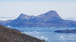
Anoritooq is located on the mainland of Greenland in the northern part of Upernavik Archipelago. To the north, Greenland icesheet drains into Sugar Loaf Bay via Cornell Glacier separating it from the base of Nuussuaq Peninsula.[1]
The nunatak has several summits, with the highest reaching 1,108 m (3,635 ft).[1] Due to the glacial retreat, another nunatak, Orsugissap Qaqqarsua, culminating in an 800 m (2,600 ft) summit, is now conjoint with Anoritooq.
74°06′58″N 56°00′00″W / 74.11611°N 56.00000°W / 74.11611; -56.00000
References
Wikimedia Commons has media related to Anoritooq.
- ^ a b Upernavik Avannarleq, Saga Map, Tage Schjøtt, 1992
- v
- t
- e
- Alison
- Baffin
- Inussulik
- Melville
- Qeqertaussap Iterlaa
- Sugar Loaf
- Tasiusaq
- Eqalugaarsuit
- Kangerluarsuk
- Kangerlussuaq (Kangeq Peninsula)
- Kangerlussuaq Icefjord
- Nasaussap Saqqaa
- Nuussuup Kangia
- Saqqarsuaq
- Sullua
- Upernavik Icefjord
- Alanngorsuup Sermia
- Cornell
- Giesecke
- Hayes
- Illullip Sermia
- Kjer
- Nunatakassaup Sermia
- Nunatakassaup Sermia (Tasiusaq Bay)
- Upernavik
| Melville Bay | |
|---|---|
| Inussulik Bay | |
| Sugar Loaf Bay |
|
| Tasiusaq Bay |
|
| Baffin Bay |
|
- Akullikassaq
- Anoritooq
- Devil's Thumb
- Inalugartuut
- Inngik
- Iviannernat
- Kangerluarsuup Qaqqarsua
- Kingittoq
- Kissavaussaq
- Kunngutip Qaqqaa
- Naajannguaq
- Naalungiussaq
- Najaarsuit Qaqqat
- Niaqornarsuaq
- Nunatakassak
- Nunatarsuaq
- Nunatarsuaq (Tasiusaq Bay)
- Nuniaat Qaqqarsua
- Orsugissap Qaqqarsua
- Paatuup Qaqqaa
- Qaqqasunnarsuaq
- Qassersuit
- Saattup Akia
- Sandersons Hope
- Toornaarsuttoq
- Tunullersuaq
- Tuttulikassak
- Umiasussuk
- Wandel Land
 | This article related to a mountain, mountain range, or peak in Greenland is a stub. You can help Wikipedia by expanding it. |
- v
- t
- e


