Darband, Tehran
Tourist area in the Alborz mountain range
Darband (Persian: دربند, [dæɾˈbænd]), formerly a village close to Tajrish, Shemiran, is a neighborhood inside Tehran's metropolitan limits.[1] It is the beginning of a hiking trail into Mount Tochal, which towers over Tehran. The Persian term darband translates to "door of the mountain" (band, a variation of vand and fand, meaning "mountain").
The start of the trail at Darband is about 250 metres long and is dotted with a number of small cafes and restaurants. These are quite popular and are busy in the evenings, as locals and tourists alike visit the many hooka lounges along the trail.[2] The Zahir-od-dowleh cemetery is also located in Darband.
Gallery
-
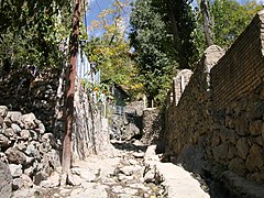 A steep path in Darband
 -
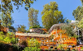 A cafe in Darband
 -
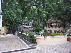 A restaurant in Darband


References
External links
 Iran portal

Wikimedia Commons has media related to Darband.
- Encyclopedia Iranica: Darband Quarter
- v
- t
- e
Main neighborhoods of Tehran
Urbanism in Iran: Tehran
- Aghdasieh
- Almahdi
- Lavizan
- Ajodanieh
- Chizar
- Darakeh
- Darband
- Darrous
- Davoodiyeh
- Doulat
- Ekhtiarieh
- Elahieh
- Farmanieh
- Gheytarieh
- Gholhak
- Jamaran
- Jordan
- Kamranieh
- Mahmoodieh
- Mehran
- Niavaran
- Pasdaran
- Shemiran
- Tajrish
- Vanak
- Valiasr
- Velenjak
- Zafaraniyeh
- Abbas Abad
- Amir Abad
- Baharestan
- Enqelab Street
- Bazar
- Hasan Abad
- Jomhuri
- Keshavarz Boulevard
- Park-e Shahr
- Seyed Khandan
- Toopkhaneh
- Yusef Abad
35°49′23.92″N 51°25′30.1″E / 35.8233111°N 51.425028°E / 35.8233111; 51.425028

 | This Shemiranat County location article is a stub. You can help Wikipedia by expanding it. |
- v
- t
- e


