Dyaul Island

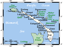
Dyaul Island (also Djaul) is an island in New Ireland Province, Papua New Guinea. Its area is 100 km2 (39 sq mi). The inhabitants live mainly in seven villages, and frequently visit Kavieng, the capital of the province, for supplies or to sell produce and fish. There are two languages, not counting Tok Pisin, spoken on Dyaul; Tigak and Tiang. Tigak is widely spoken on the western end of the island in two villages. Tiang is spoken across the remainder of the island.
References
- [1] Archived 2021-04-21 at the Wayback Machine
2°56′S 150°53′E / 2.933°S 150.883°E / -2.933; 150.883
- v
- t
- e
Islands of Papua New Guinea
- Ali
- Brumer
- D'Entrecasteaux Islands
- Dobu
- Fergusson
- Goodenough
- Normanby
- Sanaroa
- Wagifa
- Dart Reefs
- Daru
- Goaribari
- Kiwai
- Mailu
- New Guinea
- Nuakata
- Nukumanu
- Purutu
- Seleo
- Trobriands
- Tumleo
- Vitu Islands
- Wabuda
- Woodlark
- Yule
- Admiralty Islands
- Baudisson
- Bagabag
- Duke of York Islands
- Dyaul
- Feni Islands
- Karkar
- Lihir Group
- Long
- Manam
- Manne
- New Britain
- New Hanover
- New Ireland
- Patio
- Ritter
- St Matthias Islands
- Sakar
- Schouten Islands
- Selapiu
- Tabar Group
- Tanga Islands
- Tolokiwa
- Tsoilaunung
- Umboi
- Western Islands
- Bonvouloir Islands
- East
- Hastings
- Strathord Islands
- Calvados Chain
- Conflict Group
- Daloloia Group
- Deboyne Islands
- Duchateau Islands
- Dumoulin Islands
- Engineer Islands
- Misima
- Jomard Islands
- Pana Tinani
- Pocklington Reef
- Renard Islands
- Rossel (Yela)
- Samarai Islands
- Vanatinai
- Yeina
- Bougainville
- Buka
- Carteret Islands
- Green Islands
- Takuu
 Islands portal
| Authority control databases |
|
|---|
 | This article about an island in Papua New Guinea is a stub. You can help Wikipedia by expanding it. |
- v
- t
- e


 Dyaul_Island