Franconian Jura
Highland region in Germany
| Franconian Jura | |
|---|---|
 The Franconian Jura | |
| Highest point | |
| Peak | Dürrenberg |
| Elevation | 656.4 m above NN |
| Dimensions | |
| Area | 7,053.8 km2 (2,723.5 sq mi) |
| Naming | |
| Native name | 49°00′56″N 10°45′43″E / 49.01556°N 10.76194°E / 49.01556; 10.76194 |
| Parent range | South German Scarplands |
| Geology | |
| Orogeny | low mountains, cuesta |
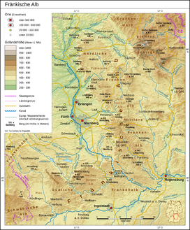
The Franconian Jura (German: Fränkische Alb [ˈfʁɛŋkɪʃə ˈʔalp] ⓘ, Fränkischer Jura, Frankenalb or Frankenjura) is an upland in Franconia, Bavaria, Germany. Located between two rivers, the Danube in the south and the Main in the north, its peaks reach elevations of up to 600 metres (2,000 ft) and it has an area of some 7053.8 km2.[1] It is part of the Table Jura (Tafeljura).
Large portions of the Franconian Jura are part of the Altmühl Valley Nature Park. The scenic meanders and gorges formed by the river Altmühl draw tourists to visit the region.
Geologically, the Franconian Jura is the eastern continuation of the Swabian Jura. The mountain chains are separated from each other by the impact crater of the Nördlinger Ries.
The northern part of the Franconian Jura is known as Franconian Switzerland (German: Fränkische Schweiz).

See also
- Bärental (Upper Franconia)
- Kalkberg (Weismain)
References
- ^ Emil Meynen, Josef Schmithüsen: Handbuch der naturräumlichen Gliederung Deutschlands. Bundesanstalt für Landeskunde, Remagen/Bad Godesberg 1953–1962 (9 editions in 8 volumes, updated map 1:1,000,000 scale with major units, 1960).
- v
- t
- e
Central Uplands of Germany
- Anterior Bavarian Forest Einödriegel
- Black Forest Feldberg
- Bohemian Forest Großer Arber (Bavarian Forest Großer Arber)
- Deister Bröhn
- Ebbe Mountains Nordhelle
- Egge Mountains (Prussian) Velmerstot
- Eifel Hohe Acht (Volcanic Eifel Ernstberg)
- Elbe Sandstone Mountains Großer Zschirnstein
- Elm Eilumer Horn
- Elster Mountains Kapellenberg
- Fichtel Mountains Schneeberg (Steinwald Platte, Kohlwald Sieben-Linden-Berg)
- Franconian Forest Döbraberg
- Franconian Jura Dürrenberg
- Gladenbach Uplands Angelburg
- Goshawk Forest Hohes Gras
- Harz Brocken (Blocksberg)
- Hildesheim Forest Griesberg
- Hils Bloße Zelle
- Hoher Meißner Kasseler Kuppe
- Hunsrück Erbeskopf (Soonwald Ellerspring)
- Ith Lauensteiner Kopf
- Kaiserstuhl Totenkopf
- Kaufungen Forest Hirschberg
- Kellerwald Wüstegarten
- Knüll Eisenberg
- Kyffhäuser Kulpenberg
- Lenne Mountains Homert
- Lippe Uplands Köterberg
- North Palatine Uplands Donnersberg
- Odenwald Katzenbuckel
- Ore Mountains Fichtelberg
- Palatine Forest Kalmit
- Rhön Wasserkuppe
- Rothaar Mountains Langenberg
- Saalhausen Hills Himberg
- Siebengebirge Großer Ölberg
- Solling Große Blöße
- Spessart Geiersberg (Breitsol)
- Sudetes Lausche (Luž) (Lusatian Mountains Lausche (Luž) (Zittau Mountains Lausche (Luž)))
- Süntel Hohe Egge
- Swabian Jura Lemberg (Randen Hoher Randen)
- Taunus Großer Feldberg
- Teutoburg Forest (Osning) Barnacken
- Thuringian Forest Großer Beerberg
- Thuringian Slate Mountains Großer Farmdenkopf
- Upper Palatine Forest Kreuzfelsen
- Vogelsberg Taufstein
- Weser Hills Paschenburg Mountain
- Westerwald Fuchskaute
- Wiehen Hills Heidbrink

Authority control databases | |
|---|---|
| International |
|
| National |
|
 | This Bavaria location article is a stub. You can help Wikipedia by expanding it. |
- v
- t
- e


