Gemerské Michalovce
Municipality of Slovakia
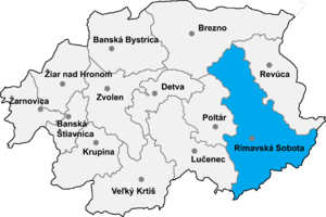
Gemerské Michalovce (Hungarian: Gömörmihályfalva) is a village and municipality in the Rimavská Sobota District of the Banská Bystrica Region of southern Slovakia.
History
In historical records the village was first mentioned in 1413 (Mychalfalwa). From 1938 to 1945 it belonged to Hungary.
Genealogical resources
The records for genealogical research are available at the state archive "Statny Archiv in Banska Bystrica, Slovakia"
- Roman Catholic church records (births/marriages/deaths): 1829-1887 (parish B)
- Lutheran church records (births/marriages/deaths): 1730-1895 (parish B)
- Reformated church records (births/marriages/deaths): 1731-1898 (parish B)
See also
External links
- https://web.archive.org/web/20080111223415/http://www.statistics.sk/mosmis/eng/run.html
- http://www.e-obce.sk/obec/gemerskemichalovce/gemerske-michalovce.html
- Surnames of living people in Gemerske Michalovce
- v
- t
- e
Municipalities of Rimavská Sobota District
- Hnúšťa
- Rimavská Sobota
- Tisovec
- Abovce
- Babinec
- Barca
- Bátka
- Belín
- Blhovce
- Bottovo
- Budikovany
- Cakov
- Čerenčany
- Čierny Potok
- Číž
- Dolné Zahorany
- Dražice
- Drienčany
- Drňa
- Dubno
- Dubovec
- Dulovo
- Figa
- Gemerček
- Gemerské Dechtáre
- Gemerské Michalovce
- Gemerský Jablonec
- Gortva
- Hajnáčka
- Hodejov
- Hodejovec
- Horné Zahorany
- Hostice
- Hostišovce
- Hrachovo
- Hrušovo
- Hubovo
- Husiná
- Chanava
- Chrámec
- Ivanice
- Janice
- Jesenské
- Jestice
- Kaloša
- Kesovce
- Klenovec
- Kociha
- Konrádovce
- Kráľ
- Kraskovo
- Krokava
- Kružno
- Kyjatice
- Lehota nad Rimavicou
- Lenartovce
- Lenka
- Lipovec
- Lukovištia
- Martinová
- Neporadza
- Nižný Skálnik
- Nová Bašta
- Orávka
- Ožďany
- Padarovce
- Pavlovce
- Petrovce
- Poproč
- Potok
- Radnovce
- Rakytník
- Ratkovská Lehota
- Ratkovská Suchá
- Riečka
- Rimavská Baňa
- Rimavská Seč
- Rimavské Brezovo
- Rimavské Janovce
- Rimavské Zalužany
- Rovné
- Rumince
- Slizké
- Stará Bašta
- Stránska
- Studená
- Sútor
- Šimonovce
- Širkovce
- Španie Pole
- Štrkovec
- Tachty
- Teplý Vrch
- Tomášovce
- Uzovská Panica
- Valice
- Včelince
- Večelkov
- Veľké Teriakovce
- Veľký Blh
- Vieska nad Blhom
- Vlkyňa
- Vyšné Valice
- Vyšný Skálnik
- Zacharovce
- Zádor
- Žíp

48°26′N 20°13′E / 48.433°N 20.217°E / 48.433; 20.217
Authority control databases | |
|---|---|
| International |
|
| National |
|
 | This article about a location in the Rimavská Sobota District of Slovakia is a stub. You can help Wikipedia by expanding it. |
- v
- t
- e


 Gemerské_Michalovce