Gložan
Village in Vojvodina, Serbia
Gložan Гложан (Serbian) Hložany (Slovak) | |
|---|---|
Village (Selo) | |
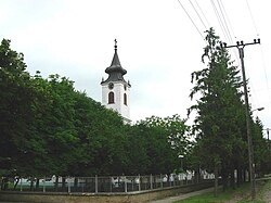 The Evangelical (Slovak) Church | |
 Map of the Bački Petrovac municipality, showing the location of Gložan | |
45°17′N 19°34′E / 45.283°N 19.567°E / 45.283; 19.567 | |
| Country |  Serbia Serbia |
| Province |  Vojvodina Vojvodina |
| Area | |
| • Total | 11.78 sq mi (30.50 km2) |
| Elevation | 272 ft (83 m) |
| Population (2022) | |
| • Total | 1,706 |
| • Density | 144.9/sq mi (55.93/km2) |
| Time zone | UTC+1 (CET) |
| • Summer (DST) | UTC+2 (CEST) |
| Area code | 381 |
Gložan (Serbian Cyrillic: Гложан) is a village located in the Bački Petrovac municipality, in the South Bačka District of Serbia. It is situated in the Autonomous Province of Vojvodina. The population of the village numbering 1,706 people (2022 census), of whom many are ethnic Slovaks.
Name
In Serbian the village is known as Gložan (Гложан); in Slovak as Hložany; and in Hungarian as Dunagálos.
Historical population
- 1961: 2,839
- 1971: 2,682
- 1981: 2,569
- 1991: 2,491
- 2002: 2,283
- 2011: 2,002
- 2022: 1,706
See also
References
- Slobodan Ćurčić, Broj stanovnika Vojvodine, Novi Sad, 1996.
- v
- t
- e
Cities, towns and villages in the South Bačka District
Seat of the district: Novi Sad
- Čelarevo
- Despotovo
- Gajdobra
- Karađorđevo
- Mladenovo
- Neštin
- Nova Gajdobra
- Obrovac
- Parage
- Pivnice
- Silbaš
- Tovariševo
- Vizić
- Bačko Gradište
- Bačko Petrovo Selo
- Mileševo
- Radičević
- Gardinovci
- Lok
- Mošorin
- Šajkaš
- Vilovo
(*) bold are municipalities or cities, 1 - Novi Sad`s urban municipalities, which aren't fully formed
45°17′N 19°34′E / 45.283°N 19.567°E / 45.283; 19.567
Wikimedia Commons has media related to Gložan.
Authority control databases | |
|---|---|
| International |
|
| National |
|
 | This South Bačka District, Vojvodina location article is a stub. You can help Wikipedia by expanding it. |
- v
- t
- e


