Lantau Peak
Mountain on Lantau Island, Hong Kong


Lantau Peak
Location of Lantau Peak in Hong Kong
 Hong Kong
| Lantau Peak | |||||||||||||
|---|---|---|---|---|---|---|---|---|---|---|---|---|---|
| Traditional Chinese | 鳳凰山 | ||||||||||||
| Simplified Chinese | 凤凰山 | ||||||||||||
| |||||||||||||
Lantau Peak or Fung Wong Shan (literally "Phoenix Mountain") is a mountain in Lantau South Country Park, Lantau Island, Hong Kong. It is the second highest peak in Hong Kong and the highest point on Lantau Island, with a height of 934 metres (3,064 ft) above the Hong Kong Principal Datum, or around 933 metres (3,061 ft) above mean sea level.[1][2][3]
Name origin
The mountain is actually made up of a pair of peaks, one is known as "Fung Shan" (male phoenix mountain) and the other as "Wong Shan" (female phoenix mountain), together they form "Fung Wong Shan".
Location

Lantau Peak is located within Lantau South Country Park, near the center of Lantau Island, and west of Sunset Peak, which is the second-highest peak on the island. Lantau Peak is reachable by the Lantau Trail. At the foot of Lantau Peak, a tourist spot called the Wisdom Path (心經簡林) can be found.[4]
Geology
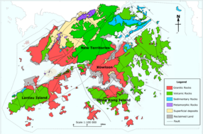
Lantau Peak is formed by Volcanic rocks, including porphyritic rhyolites,[5] like many of the tallest mountains in Hong Kong, such as Tai Mo Shan. Some shorter mountains in Hong Kong are formed by older Granitic rocks.
Lantau Peak is also the source of water for Tung Chung River, a major river on Lantau Island.[6]
Climate
Lantau Peak is located in central Lantau Island, with an elevation of 934 meters above sea level (23 metres shorter than Tai Mo Shan, Hong Kong's highest peak).[1] Under the Köppen climate classification, Lantau Peak features a subtropical highland climate. Due to its elevation, strong winds and fog occur throughout the year. Winter is cold with temperatures often dipping below 0 °C; summer is warm with temperatures reaching tops of 18-22 °C; spring is cool and humid; autumn is cool and dry. Because there is no weather station at the top of Lantau Peak (934m), the Ngong Ping Weather Station of the Hong Kong Observatory (593m)[7] can be used as reference for the temperature at the summit.
| Climate data for Lantau Peak | |||||||||||||
|---|---|---|---|---|---|---|---|---|---|---|---|---|---|
| Month | Jan | Feb | Mar | Apr | May | Jun | Jul | Aug | Sep | Oct | Nov | Dec | Year |
| Mean daily maximum °C (°F) | 8.3 (46.9) | 10.2 (50.4) | 11.9 (53.4) | 14.2 (57.6) | 16.6 (61.9) | 17.8 (64.0) | 18.5 (65.3) | 19.2 (66.6) | 18.7 (65.7) | 16.6 (61.9) | 13.5 (56.3) | 10.0 (50.0) | 14.6 (58.3) |
| Daily mean °C (°F) | 4.9 (40.8) | 7.2 (45.0) | 9.0 (48.2) | 13.1 (55.6) | 14.8 (58.6) | 16.3 (61.3) | 16.9 (62.4) | 17.1 (62.8) | 16.3 (61.3) | 13.8 (56.8) | 10.6 (51.1) | 6.8 (44.2) | 12.2 (54.0) |
| Mean daily minimum °C (°F) | 2.3 (36.1) | 4.9 (40.8) | 6.8 (44.2) | 10.0 (50.0) | 13.1 (55.6) | 14.7 (58.5) | 15.3 (59.5) | 15.3 (59.5) | 14.5 (58.1) | 11.9 (53.4) | 8.4 (47.1) | 4.2 (39.6) | 10.1 (50.2) |
| Source: Climate Data for Lantau Peak — Hong Kong Observatory | |||||||||||||

See also
Wikimedia Commons has media related to Lantau Peak.
References
- ^ a b "Lantau South". www.afcd.gov.hk. Retrieved 18 September 2019.
- ^ Lands Department (January 2023). "Hong Kong Geographic Data" (PDF).
- ^ Lands Department (2018). "Explanatory Notes on Geodetic Datums in Hong Kong" (PDF).
- ^ "Tourism Commission - Completed". www.tourism.gov.hk. Retrieved 18 September 2019.
- ^ "Lantau Volcanic Group (undifferentiated) - Jlu". www.cedd.gov.hk. Retrieved 26 April 2020.
- ^ "JC WISE - Rivers@HK Database | Faculty of Social Sciences, HKU". www.jcwise.hk. Retrieved 15 April 2021.
- ^ "Variation of Wind Direction and Speed". www.hko.gov.hk. Retrieved 18 September 2019.
- v
- t
- e
- Tai Mo Shan
- Lantau Peak
- Sunset Peak
- The Hunch Backs
- Yin Ngam Teng
- Wo Tong Kong
- Grassy Hill
- Wong Leng
- Buffalo Hill
- West Buffalo Hill
- Kowloon Peak
- Shun Yeung Fung
- Tiu Shau Ngam
- Chau Ma Kong
- Middle Hill
- Lo Tin Teng
- Kai Kung Leng (Lam Tsuen)
- Castle Peak
- Lin Fa Shan (Tsuen Wan)
- Tate's Cairn
- Tai To Yan
- Wong Chuk Shan
- Victoria Peak
- Kwun Yam Shan (Yuen Long)
- Lai Pek Shan
- Tung Shan
- Chung Li Fung
- Shek Nga Shan
- Kau Nga Ling
- Pyramid Hill
- Tung Yeung Shan
- Needle Hill
- Mount Parker
- Kao Lao Fung
- Kuai Li Fung
- Pok To Yan
- Fu Yung Pit
- Hsien Ku Fung
- Sheung Tsz Fung
- Tsao Kau Fung
- Pak Tai To Yan
- Kau Keng Shan
- Mount Kellett
(excerpt)
- Lion Rock
- High West
- Sze Tsz Tau Shan
- Robin's Nest
- Ling Wui Shan
- Choi Wo Fung
- Hung Fa Chai
- Temple Hill
- Kwai Tau Leng
- Por Kai Shan
- Shek Uk Shan
- Muk Yue Shan
- Mount Gough
- Shek Lung Kung
- Sharp Peak
- Tai Hom Sham
- Wo Sheung Tung
- Lo Fu Tau
- Tin Fu Tsai Shan
- Keung Shan
- Beacon Hill
- Ngam Tau Shan
- Cheung Shan (Lantau Island)
- Cheung Yan Shan
- Cloudy Hill
- Mount Cameron
- Unicorn Ridge
- Mount Butler
- Kwun Yam Shan (Lantau)
- Violet Hill
- Jardine's Lookout
- Razor Hill
- Mount Nicholson
- Sham Hang Lek
- Middle Kau Nga Ling
- Siu Ma Shan
- Ngau Yee Shek Shan
- Tiu Tang Lung
- Luk Chau Shan
- Tai Cham Koi
- Luk Shan
(excerpt)
- Tai Sheung Tok
- Kai Kung Shan (Sai Kung)
- Kau To Shan
- Turret Hill
- Hebe Hill
- Wa Mei Shan
- The Twins South
- Lui Ta Shek
- Lau Fa Tung
- Yuen Tau Shan
- Nga Ying Shan
- Sugar Loaf Peak
- Kai Kung Shan (Lam Tsuen)
- Mount Hallowes
- Tai Mun Shan
- Golden Hill
- Fan Kei Tok
- Tin Mei Shan
- The Twins North
- Bird's Hill
- Cham Tin Shan
- Mount Stenhouse
- Mount Collinson
- Lower Hebe Hill
- High Junk Peak
- Cheung Lin Shan
- Shek Sze Shan
- Tsim Fung Shan
- Smuggler's Ridge
- Tsing Yi Peak
- Miu Tsai Tun
- D'Aguilar Peak
- Wo Liu Tun
- Sze Shan
- Tai Tun
- Sai Wan Shan (Sai Kung)
- Pottinger Peak
- Kwai Au Shan
- Eagle's Nest
- Black Hill
- Kwun Yam Tung
- Lo Yan Shan
- Tai Che Tung
- Tap Chai Shan
(excerpt)
- Tung Wan Shan
- Kung Um Shan
- Ma Tau Fung
- Tit Sze Kou
- Tai Leng Tung
- Tai Shan
- Brick Hill
- Shek O Peak
- Tai She Teng
- Tai Ngau Wu Teng
- Tin Ha Shan
- Fa Ping Teng
- Mount Davis
- Wan Cham Shan
- Ngau Wu Tun
- Kei Lak Chai
- Lung Fu Shan
- Ngo Sei Kai
- Sheung Yeung Shan
- Kwai Shan
- Ling Kok Shan
- Chiu Keng Wan Shan
- Tin Wan Shan
- Mau Wu Shan
- Bennet's Hill
- Tung Tau Teng
- Wang Tau Tun
- Nam Tong Teng
- Hung Heung Lo Fung
- Tai Yue Ngam Teng
- Piper's Hill
- Devil’s Peak
- Cheung Ngau Shan
- Kei Lun Shan
- San Sin Tseng Shan
- Tiu Chung Tai Shan
- Ping Tok Hang Shan
- Fa Shan
- Pai Tau Tun
- Cheung Ngau Shan
- Braemar Hill
- Boa Vista
- Pak Kok Shan
(excerpt)
- Sai Wan Shan (Chai Wan)
- Mount Johnston
- Crow's Nest
- Ping Shan
- Tai Yam Teng
- Shum Wan Shan
- Sha Tin Heights
- Cheung Shan (North District)
- Obelisk Hill
- Hammer Hill
- Cheung Shan (Sai Kung)
- Tai Ling (North District)
- Ho Hok Shan
- Fake Yuk Kwai Shan
- Siu Lam Hill
- Shouson Hill
- Ngai Tau
- Red Hill
- To Fung Shan
- Po Keng Teng
- Chung Hom Shan
- Cheung Pai Tun
- Kai Shan
- Kai Kung Leng (Kat O)
- Por Lo Shan
- Hung Tang Shan
- Crest Hill
- Duckling Hill
- Red Light Hill
(excerpt)
- Checkerboard Hill
- Pak Fu Shan
- Finger Hill
- Wong Shek
- Garden Hill
- Woh Chai Shan
- Diamond Hill
- Scenic Hill
- Pak Hok Shan
- Fu Shan
- Lo Shue Leng
- Yuen Chau Kok
- Cha Kwo Ling
- Tai Tseng Shan
- Duke's Hill
- Ko Po Shan
- Chu Wong Ling
- King's Park Hill
- Signal Hill
- Crocodile Hill
- Kadoorie Hill
- Sai Shan
- Observatory Hill
- Lung Shan (Ngau Tau Kok)
- Hok Ngam Teng
- Leighton Hill
- Quarry Hill
- Hung Hom Hill
- Lo Lung Hang Hill
- Shan Pui Leng
- Pak Fa Leng
- Mount Parish
- Mount Shadwell
- Caroline Hill
- Hong Kong Three Sharp Peaks
- Sai Kung Three Sharp Peaks
- Dragon's Back
- Eight Mountains of Kowloon
- Mini Pat Sin
- 4 Hills of Kowloon
- The Twins
- Pat Sin Leng
- Wong Leng
- Castle Peak Hinterland
- Four Guardian Beasts of Tai O
- Kai Kung Leng (Lam Tsuen)
| Authority control databases: National |
|
|---|
 | This article related to a mountain or hill in Hong Kong is a stub. You can help Wikipedia by expanding it. |
- v
- t
- e
 | This New Territories location article is a stub. You can help Wikipedia by expanding it. |
- v
- t
- e


