Morigerati
You can help expand this article with text translated from the corresponding article in Italian. (January 2022) Click [show] for important translation instructions.
- Machine translation, like DeepL or Google Translate, is a useful starting point for translations, but translators must revise errors as necessary and confirm that the translation is accurate, rather than simply copy-pasting machine-translated text into the English Wikipedia.
- Do not translate text that appears unreliable or low-quality. If possible, verify the text with references provided in the foreign-language article.
- You must provide copyright attribution in the edit summary accompanying your translation by providing an interlanguage link to the source of your translation. A model attribution edit summary is
Content in this edit is translated from the existing Italian Wikipedia article at [[:it:Morigerati]]; see its history for attribution. - You may also add the template
{{Translated|it|Morigerati}}to the talk page. - For more guidance, see Wikipedia:Translation.
Comune in Campania, Italy
Morigerati | |
|---|---|
Comune | |
| Comune di Morigerati | |
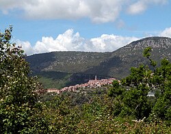 View from the surrounding mountains | |
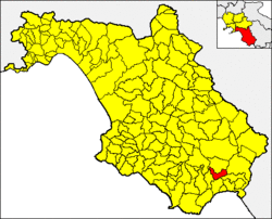 Morigerati within the Province of Salerno | |
Location of Morigerati  | |
40°08′24.4″N 15°33′18.9″E / 40.140111°N 15.555250°E / 40.140111; 15.555250 | |
| Country | Italy |
| Region | Campania |
| Province | Salerno (SA) |
| Frazioni | Sicilì |
| Government | |
| • Mayor | Vincenzina Prota |
| Area [1] | |
| • Total | 21.19 km2 (8.18 sq mi) |
| Population (28 February 2017)[2] | |
| • Total | 665 |
| • Density | 31/km2 (81/sq mi) |
| Time zone | UTC+1 (CET) |
| • Summer (DST) | UTC+2 (CEST) |
| Postal code | 84030 |
| Dialing code | 0974 |
| Patron saint | Demetrius of Thessaloniki |
| Saint day | 26 August |
| Website | Official website |


Morigerati (Cilentan: Murgirati) is a town and comune in the province of Salerno in the Campania region of south-western Italy.
History
The village was probably founded by the ancient Italic people of the Morgetes. It was later colonized by the Ancient Roman, as witnessed by some ruins in a locality named Rumanuru.[3]
Geography
The municipality, located in southern Cilento and part of its national park, is crossed by the Bussento river. It borders with Casaletto Spartano, Caselle in Pittari, Santa Marina, Torre Orsaia and Tortorella.[4] Its only hamlet (frazione) is the village of Sicilì, that has a population of 364.[5]
Main sights
- Bussento Caves, a WWF oasis along Bussento river. It is a nature reserve that includes gorges and caves by the river.[6][7]
- The local Ethnographic Museum[8]
Transport
The town is served by the national highway SS 517/var Padula-Policastro at the exit "Sicilì-Morigerati", 11 km west. The highway links the Cilentan highway to the A3 Motorway.
See also
References
- ^ "Superficie di Comuni Province e Regioni italiane al 9 ottobre 2011". Italian National Institute of Statistics. Retrieved 16 March 2019.
- ^ (in Italian) Source: ISTAT 2016
- ^ Morigerati on bussento.it
- ^ 40301
(x a j h)Morigerati on OpenStreetMap - ^ (in Italian) Sicilì on italia.indettaglio.it
- ^ (in Italian) Bussento Caves (WWF.it website)
- ^ (in Italian) WWF Oasis of Bussento on Morigerati website
- ^ (in Italian) Ethnographic Museum of Morigerati
External links
Wikimedia Commons has media related to Morigerati.
- (in Italian) Morigerati official website
- (in Italian) Ethnographic Museum of Morigerati
- v
- t
- e
- Acerno
- Agropoli
- Albanella
- Alfano
- Altavilla Silentina
- Amalfi
- Angri
- Aquara
- Ascea
- Atena Lucana
- Atrani
- Auletta
- Baronissi
- Battipaglia
- Bellizzi
- Bellosguardo
- Bracigliano
- Buccino
- Buonabitacolo
- Caggiano
- Calvanico
- Camerota
- Campagna
- Campora
- Cannalonga
- Capaccio
- Casal Velino
- Casalbuono
- Casaletto Spartano
- Caselle in Pittari
- Castel San Giorgio
- Castel San Lorenzo
- Castelcivita
- Castellabate
- Castelnuovo Cilento
- Castelnuovo di Conza
- Castiglione del Genovesi
- Cava de' Tirreni
- Celle di Bulgheria
- Centola
- Ceraso
- Cetara
- Cicerale
- Colliano
- Conca dei Marini
- Controne
- Contursi Terme
- Corbara
- Corleto Monforte
- Cuccaro Vetere
- Eboli
- Felitto
- Fisciano
- Furore
- Futani
- Giffoni Sei Casali
- Giffoni Valle Piana
- Gioi
- Giungano
- Ispani
- Laureana Cilento
- Laurino
- Laurito
- Laviano
- Lustra
- Magliano Vetere
- Maiori
- Mercato San Severino
- Minori
- Moio della Civitella
- Montano Antilia
- Monte San Giacomo
- Montecorice
- Montecorvino Pugliano
- Montecorvino Rovella
- Monteforte Cilento
- Montesano sulla Marcellana
- Morigerati
- Nocera Inferiore
- Nocera Superiore
- Novi Velia
- Ogliastro Cilento
- Olevano sul Tusciano
- Oliveto Citra
- Omignano
- Orria
- Ottati
- Padula
- Pagani
- Palomonte
- Pellezzano
- Perdifumo
- Perito
- Pertosa
- Petina
- Piaggine
- Pisciotta
- Polla
- Pollica
- Pontecagnano Faiano
- Positano
- Postiglione
- Praiano
- Prignano Cilento
- Ravello
- Ricigliano
- Roccadaspide
- Roccagloriosa
- Roccapiemonte
- Rofrano
- Romagnano al Monte
- Roscigno
- Rutino
- Sacco
- Sala Consilina
- Salento
- Salerno
- Salvitelle
- San Cipriano Picentino
- San Giovanni a Piro
- San Gregorio Magno
- San Mango Piemonte
- San Marzano sul Sarno
- San Mauro Cilento
- San Mauro la Bruca
- San Pietro al Tanagro
- San Rufo
- San Valentino Torio
- Sant'Angelo a Fasanella
- Sant'Arsenio
- Sant'Egidio del Monte Albino
- Santa Marina
- Santomenna
- Sanza
- Sapri
- Sarno
- Sassano
- Scafati
- Scala
- Serramezzana
- Serre
- Sessa Cilento
- Siano
- Sicignano degli Alburni
- Stella Cilento
- Stio
- Teggiano
- Torchiara
- Torraca
- Torre Orsaia
- Tortorella
- Tramonti
- Trentinara
- Valle dell'Angelo
- Vallo della Lucania
- Valva
- Vibonati
- Vietri sul Mare
 | This Campanian location article is a stub. You can help Wikipedia by expanding it. |
- v
- t
- e


