Tjerkgaast
Village in Friesland, Netherlands
Tjerkgaast Tsjerkgaast | |
|---|---|
Village | |
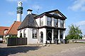
 Tjerkgaast church | |
 Location in the former Skarsterlân municipality | |
52°54′14″N 5°40′43″E / 52.90389°N 5.67861°E / 52.90389; 5.67861 | |
| Country |  Netherlands Netherlands |
| Province |  Friesland Friesland |
| Municipality |  De Fryske Marren De Fryske Marren |
| Area [1] | |
| • Total | 19.24 km2 (7.43 sq mi) |
| Elevation [2] | −0.6 m (−2.0 ft) |
| Population (2021)[1] | |
| • Total | 350 |
| • Density | 18/km2 (47/sq mi) |
| Postal code | 8522[1] |
| Dialing code | 0514 |
Tjerkgaast (West Frisian: Tsjerkgaast) is a village in De Fryske Marren municipality in the province of Friesland, the Netherlands. It had a population of around 380 in 2017.[3]
History
The village was first mentioned in 1413 as Tzerckgeest, and means church on high sandy ridge.[4] Tjerkgaast is a road village which centres around the church. The church was built in 1703 as a replacement of the medieval predecessor. The western wall is a remainder of the older church. Huize Spannenburg is a neoclassical building from 1845 and has been built as a replacement of the Douma State which had been built in 1793 in Langweer.[5] In 1840, Tjerkgaast was home to 210 people.[6]
Before 2014, Tjerkgaast was part of the Skarsterlân municipality and before 1984 it was part of Doniawerstal.[6]
Gallery
-
 Huize Spanneburg
 -
 The Eye statue
 -
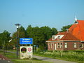 Welcome to Tjerkgaast
 -
 Galamastate


References
- ^ a b c "Kerncijfers wijken en buurten 2021". Central Bureau of Statistics. Retrieved 30 March 2022.
- ^ "Postcodetool for 8522MD". Actueel Hoogtebestand Nederland (in Dutch). Het Waterschapshuis. Retrieved 29 March 2022.
- ^ Kerncijfers wijken en buurten 2017 - CBS
- ^ "Tjerkgaast - (geografische naam)". Etymologiebank (in Dutch). Retrieved 30 March 2022.
- ^ Ronald Stenvert & Sabine Broekhoven (2000). "Tjerkgaast" (in Dutch). Zwolle: Waanders. ISBN 90 400 9476 4. Retrieved 30 March 2022.
- ^ a b "Tjerkgaast". Plaatsengids (in Dutch). Retrieved 30 March 2022.
External links
![]() Media related to Tjerkgaast at Wikimedia Commons
Media related to Tjerkgaast at Wikimedia Commons
- v
- t
- e
Populated places in the municipality of De Fryske Marren
- Joure
- Lemmer
- Sloten
- Former municipalities: Gaasterlân-Sleat
- Lemsterland
- Skarsterlân
- Akmarijp
- Bakhuizen
- Balk
- Bantega
- Boornzwaag
- Broek
- Delfstrahuizen
- Dijken
- Doniaga
- Echten
- Echtenerbrug
- Eesterga
- Elahuizen
- Follega
- Goingarijp
- Harich
- Haskerhorne
- Idskenhuizen
- Kolderwolde
- Langweer
- Legemeer
- Mirns
- Nijehaske
- Nijemirdum
- Oldeouwer
- Oosterzee
- Oudega
- Oudehaske
- Oudemirdum
- Ouwster-Nijega
- Ouwsterhaule
- Rijs
- Rohel
- Rotstergaast
- Rotsterhaule
- Rottum
- Ruigahuizen
- Scharsterbrug
- Sint Nicolaasga
- Sintjohannesga
- Snikzwaag
- Sondel
- Terherne
- Terkaple
- Teroele
- Tjerkgaast
- Vegelinsoord
- Wijckel
 | This Friesland location article is a stub. You can help Wikipedia by expanding it. |
- v
- t
- e


