Weepecket Islands
Islands in Massachusetts, United States
41°31′00″N 70°44′08″W / 41.5167749°N 70.7355863°W / 41.5167749; -70.7355863[1]United States
| The Elizabeth Islands |
|---|
 |
| Major islands |
|
| Minor islands |
|
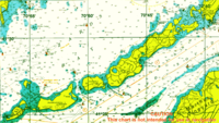
The Weepecket Islands are a group of three islands which are part of the Elizabeth Islands of Dukes County, Massachusetts, United States. They are located off the north shore of Naushon Island, the largest of the Elizabeth Islands. Together the three Weepeckets have a land area of 0.051 km2 (0.02 sq mi, or 12.6 acres). The islands were used as a United States Navy practice target range (the Weepecket Island Bomb Area) for bombs, rockets, and machine guns from 1941 to 1957.[2]
Today, the islands are uninhabited.[3] and are a popular breeding ground for double-crested cormorants.
See also
References
- ^ "Weepecket Islands". Geographic Names Information System. United States Geological Survey, United States Department of the Interior. Retrieved 2018-08-20.
- ^ "Weepecket Islands-U.S. Navy Bombing Practice Area" (PDF). United States Army Corps of Engineers. Retrieved 20 July 2013.
- ^ "U.S. Census website". United States Census Bureau. Retrieved 2006-06-24.
- v
- t
- e
Islands and peninsulas of Massachusetts
- Abnecotants Island
- Adams Island
- Amrita Island
- Angelica Rock
- Apple Island
- Averills Island
- Bachelor Island
- Bakers Island
- Bar Rock (Scituate)
- Baret Island
- Barton Island
- Bassetts Island
- Bates Island
- Beaver Island
- Big Pine Island
- Big Quamino Rock
- Billingsgate Island
- Bird Island
- Black Rock
- Blueberry Island
- Boston Ledge
- Brant Island
- Brant Rock
- Bumpkin Island
- Busta Rhymes Island
- Button Island
- Calf Island
- Carrick Island
- Castle Rock
- Cemetery Island
- Chappaquiddick Island
- Children's Island
- Childs Island
- Choate Island
- Chubb Island
- Clark Island
- Clark's Island
- Cleveland Island
- Cobble Island
- Coney Island
- Conspiracy Island
- Cormorant Rock (Marblehead)
- Corn Island
- Cove Ledge
- Crow Island
- Crowninshield Island
- Cuttyhunk Island
- Decatur Rock
- Deer Island (Amesbury)
- Dole Island
- Egg Rock (Concord)
- Egg Rock (Nahant)
- Elizabeth Islands
- Fish Island
- Gallops Island
- Georges Island
- Gooseberry Island
- Governors Island
- Grand Island
- Grape Island (Weymouth)
- Grape Island (Ipswich)
- Great Brewster Island
- Green Island
- Gull Island
- Hales Island
- Hangman Island
- Holy Island
- House Island
- Langlee Island
- Little Brewster Island
- Long Island
- Lovells Island
- Marblehead Rock
- Martha's Vineyard
- Middle Brewster Island
- Misery Islands
- Monomoy Island
- Moon Island
- Muskeget Island
- Nahant
- Nantucket
- Nashawena Island
- Naushon Island
- Nixes Mate
- Noddle's Island
- Nomans Land
- Nonamesset Island
- Nut Island
- Onset Island
- Outer Brewster Island
- Pasque Island
- Peddocks Island
- Penikese Island
- Plum Island
- Popponesset Island
- Popponesset Spit
- Raccoon Island
- Ragged Island
- Rainsford Island
- Sampsons Island
- Sarah Island
- Shag Rocks
- Slate Island
- Snake Island
- Spectacle Island
- Spinnaker Island
- Stall Hill Island
- Tewksbury Rock
- Thacher Island
- The Graves
- Thompson Island
- Three and One-half Fathom Ledge
- Tinker's Island
- Tuckernuck Island
- Uncatena Island
- Veckatimest Island
- Washburn Island
- Weepecket Islands
- West Island
- Wickets Island
- Winter Island
- Cape Ann
- Cape Cod
- Castle Island
- Charles River Peninsula
- Charlestown Neck
- Columbia Point
- Deer Island
- Houghs Neck
- Humarock
- Pemberton Point
- Popponesset Peninsula
- Ram Head
- Rocky Point
- Rose Point
- Salem Neck
- Shawmut Peninsula
- Wings Neck
- World's End
 | This Dukes County, Massachusetts geography–related article is a stub. You can help Wikipedia by expanding it. |
- v
- t
- e


 Weepecket_Islands