Westwood Boulevard
Major street in Los Angeles, California

Westwood Boulevard is a street in Los Angeles that runs through the heart of Westwood Village and further south in West Los Angeles.
Route

Westwood Boulevard begins south of Sunset Boulevard in the campus of UCLA as Westwood Plaza. After exiting UCLA, it is one of two major thoroughfares in Westwood Village. Its intersection with Wilshire Boulevard is one of the busiest in Los Angeles, with seven through lanes and four left turn lanes (going east/west). Most of the large office buildings in Westwood are located on Wilshire Boulevard.
South of Wilshire, Westwood Boulevard continues as a four-lane boulevard passing through many small businesses. This area of Westwood south of Wilshire Boulevard is often referred to as Tehrangeles because of its large Iranian-American population. Many of the businesses along Westwood Boulevard are Persian, reflecting these demographics. In particular, Westwood Boulevard is noted for a large number of Persian restaurants. Farther south, the Westside Pavilion Mall was formerly located at Westwood Boulevard's intersection with Pico Boulevard.
Westwood Boulevard ends south of National Boulevard in the Palms neighborhood of Los Angeles, as it curves to the east and turns into National Place. Later, National Place becomes National Boulevard when it crosses Overland Avenue. At this point, Westwood Boulevard is a primarily residential street.
Westwood Boulevard comes back further south at Charnock Road and finally ends on Washington Boulevard.
Plans to install bike lanes near UCLA have been contentious, with opponents claiming they would worsen traffic.[1]
Transportation
- Santa Monica Freeway (Interstate 10, formerly US Route 66) crosses over Westwood Boulevard.
- Santa Monica Transit lines 8 and 12 run through Westwood Boulevard.
- The Metro E Line operates a rail station at Exposition Boulevard.
Notable landmarks
- Holmby Hall
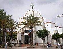
- Janss Dome[2]
- Ralphs Grocery Store building (Bratskeller - Egyptian Theater)[2]
- Crest Theatre[2]
- Hammer Museum
- Ronald Reagan UCLA Medical Center
- Westside Pavilion
- Liberal Arts Masonic Temple
References
- ^ Weikel, Dan (July 21, 2015). "Westwood bike lane proposal ignites strong feelings on both sides". Los Angeles Times. Retrieved September 13, 2015.
- ^ a b c Los Angeles Department of City Planning (September 7, 2007), Historic - Cultural Monuments (HCM) Listing: City Declared Monuments (PDF), City of Los Angeles, retrieved 2009-01-28
External links
KML file (edit • help)
Template:Attached KML/Westwood Boulevard
KML is from Wikidata
- v
- t
- e
- Alameda St.
- Alvarado St.
- Atlantic Blvd./Atlantic Ave.
- Avalon Blvd.
- Aviation Blvd.
- Azusa Ave.
- Beverly Dr.
- Beverly Glen Blvd.
- Broadway
- Cahuenga Blvd.
- Central Ave.
- Crenshaw Blvd.
- Doheny Dr.
- Fairfax Ave.
- Fair Oaks Ave.
- Figueroa St.
- Garfield Ave./Cherry Ave.
- Glendale Blvd./Brand Blvd.
- Gower St.
- Grand Ave.
- Highland Ave.
- Hill St.
- Hoover
- La Brea Ave./Hawthorne Blvd.
- La Cienega Blvd.
- Lake Ave.
- Laurel Canyon Blvd./Crescent Heights Blvd.
- Lincoln Blvd.
- Los Angeles St.
- Main St.
- Normandie Ave.
- Ocean Ave.
- Orange Grove Blvd.
- Robertson Blvd.
- Rosemead Blvd./Lakewood Blvd.
- San Fernando Rd.
- San Pedro St.
- Sawtelle Blvd.
- Sepulveda Blvd.
- Sierra Hwy.
- Sierra Madre Blvd.
- Soto St.
- Pacific Blvd./Long Beach Blvd.
- Pacific Coast Hwy.
- Vermont Ave.
- Vine St.
- Western Ave.
- Westwood Blvd.
- Wilcox Ave.
- Adams Blvd.
- Alondra Blvd.
- Angeles Crest Hwy.
- Arrow Hwy.
- Artesia Blvd.
- Bandini Blvd.
- Beverly Blvd.
- Carroll Ave.
- Carson St.
- Century Blvd.
- Colima Rd./Golden Springs Dr.
- Compton Blvd./Marine Ave.
- Culver Blvd.
- Del Amo Blvd.
- El Segundo Blvd.
- Florence Ave.
- Franklin Ave.
- Garvey Ave.
- Hollywood Blvd.
- Huntington Dr.
- Imperial Hwy.
- Jefferson Blvd.
- Lomita Blvd.
- Los Feliz Blvd.
- Manchester Ave./Firestone Blvd.
- Manhattan Beach Blvd.
- Martin Luther King Jr. Blvd.
- Melrose Ave.
- Montana Ave.
- Mulholland Dr.
- Nadeau
- Obama Blvd.
- Olympic Blvd.
- Pico Blvd.
- Rosecrans Ave.
- Santa Monica Blvd.
- Slauson Ave.
- Sunset Blvd./Cesar Chavez Ave.
- Temple St.
- Vernon Ave.
- Venice Blvd.
- Washington Blvd.
- Whittier Blvd.
- Wilshire Blvd.
- Arrow Hwy.
- Balboa Blvd.
- Burbank Blvd.
- Cahuenga Blvd.
- Coldwater Canyon Ave.
- Colorado Blvd.
- De Soto Ave.
- Devonshire St.
- Foothill Blvd.
- Glenoaks Blvd.
- Lankershim Blvd.
- Laurel Canyon Blvd.
- Magnolia Blvd.
- Mulholland Dr.
- Nordhoff St.
- Reseda Blvd.
- Riverside Dr.
- Roscoe Blvd.
- San Fernando Rd.
- Sepulveda Blvd.
- Sierra Hwy.
- Sherman Way
- Sunland Blvd./Vineland Ave.
- Topanga Canyon Blvd.
- Valley Blvd.
- Van Nuys Blvd.
- Ventura Blvd.
- Victory Blvd.
traffic circles
- Gower Gulch
- Hollywood and Vine
- Naud Junction
- SM Entertainment Square
- Sunset Junction
- Abbot Kinney Blvd.
- California Incline
- Centinela Ave./Bundy Dr.
- Pacific Coast Hwy.
- San Vicente Blvd.
- Telegraph Rd.
- Gaffey St.
- Western Ave.
- 77 Sunset Strip
- "All I Wanna Do"
- "Blue Jay Way"
- "Dead Man's Curve"
- "Down Rodeo"
- "Free Fallin'"
- "I Love L.A."
- King of the Mountain
- "LA Devotee"
- Mulholland Drive
- "Pico and Sepulveda"
- Sunset Boulevard (film, musical)
- Vine Street (+Live+ song)
All un-suffixed roads are streets unless otherwise noted.
 | This California road–related article is a stub. You can help Wikipedia by expanding it. |
- v
- t
- e


